貝類養殖區禁制公告與說明
編號 049-004,約克河上游
自 2026 年 7 月 15 日起生效
根據第 28.2 卷,第 8 章,第 §§ 28.2-803 條至 28.2-808 條,第 § 32.1-20 條,以及第 § 2.2-4002 條,Virginia Code B.16。
1。「上約克河 (Upper York River) 第 049-004 號貝類區域禁制公告與說明」於 2025 年 9 月 15 日生效,現已取消,自 2026 年 7 月 15 日起生效。
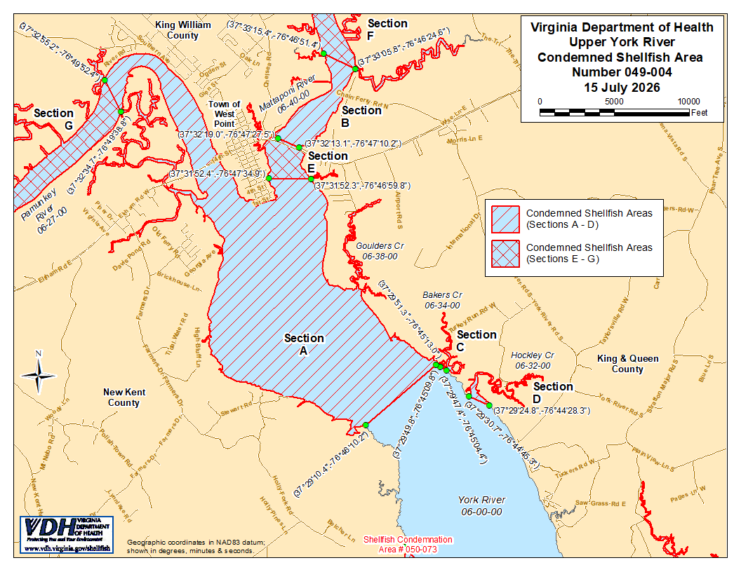
2。編號 049-004 貝類禁採區(顯示為 A 至 G 區)茲此設立,於 2026 年 7 月 15 日生效。關於 A 至 D 節,任何個人、公司或法人出於任何目的從這些區域捕撈貝類均屬違法,但根據《Virginia 法典》第 28.2-810 節,經 Marine Resources Commission 許可者不在此限。關於 E 至 G 區,任何個人、公司或法人出於任何目的從這些區域採集貝類均屬違法。這些區域的邊界顯示於題為「上約克河 (Upper York River),編號 049-004 貝類禁採區,2026 年 7 月 15 日」的地圖上,該地圖為本公告的一部分。
3。衛生署將隨時接收、審議並回覆任何利害關係人針對本命令之重新審議或修訂所提出之請願。
徵收區域編號 049-004 之邊界
A. 禁止捕撈區域應包括約克河 (York River) 及其支流位於緯度/經度地圖座標 (37°29'10.4",-76°46'10.2") 與地圖座標 (37°29'51.3",-76°45'13.0") 之間連線的上游部分;但不包括定義為 D、E、F 和 G 節的區域。
B. 被禁制區域應包含 Mattaponi 河位於由緯度/經度地圖座標 (37°32'19.0",-76°47'27.5") 與地圖座標 (37°32'13.1",-76°47'10.2") 之間所劃定之線段上游的部分;但不包含定義為 F 節的區域。
C. 禁止區域應包括 Bakers Creek 位於緯度/經度地圖座標 (37°29'49.8",-76°45'09.8") 與地圖座標 (37°29'47.4",-76°45'04.4") 之間連線的上游所有區域。
D. 被禁制區域應包含 Hockley Creek 位於緯度/經度地圖座標 (37°29'30.7",-76°44'45.3") 與地圖座標 (37°29'24.8",-76°44'28.3") 之間連線的上游所有水域。
E. 禁止捕撈區域應包括 Mattaponi 河位於緯度/經度地圖座標 (37°31'52.4",-76°47'34.9") 與地圖座標 (37°31'52.3",-76°46'59.8") 之間連線的上游部分;但不包括定義為 B 節和 F 節的區域。
F. 禁制區域應包含 Mattaponi 河位於緯度/經度地圖座標 (37°33'15.4",",-76°46'51.4"") 與地圖座標 (37°33'05.8",",-76°46'24.6"") 之間連線的上游部分。
G. 禁區應包括 Pamunkey River 位於緯度/經度地圖座標 (37°32'34.7",-76°49'38.8") 與地圖座標 (37°32'55.2",-76°49'52.4") 之間連線的上游部分。