貝類養殖區禁制公告與說明
編號 035-076,上皮安卡坦克河 (UPPER PIANKATANK RIVER)
自 2026 年 11 月 15 日起生效
根據第 28.2 卷,第 8 章,第 §§ 28.2-803 條至 28.2-808 條,第 § 32.1-20 條,以及第 § 2.2-4002 條,Virginia 法典第 B.16 條:
1. The “Notice and Description of Shellfish Area Condemnation Number 035-076, Upper Piankatank River,” effective 15 February 2025, is cancelled effective 15 November 2026.
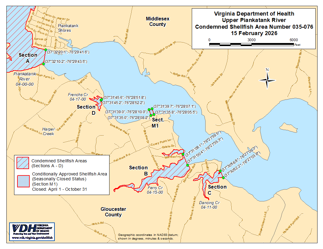
2. Condemned Shellfish Area Number 035-076, shown as Sections A through D, is established effective 15 November 2026. It shall be unlawful for any person, firm, or corporation to take shellfish from these areas for any purpose, except by permit granted by the Marine Resources Commission, as provided in § 28.2-810 of the Code of Virginia. The boundaries of these areas are shown on the map titled “Upper Piankatank River, Condemned Shellfish Area Number 035-076, 15 November 2026” which is part of this notice.
3. Conditionally Approved Shellfish Area (seasonally closed status) Number 035-076, shown as Section M1, is hereby established, effective 15 November 2026, and shall remain in force annually thereafter for the period beginning the first day of April through the last day of October until rescinded. It shall be unlawful for any person, firm, or corporation to take shellfish from this area while in the closed status, except by permit granted by the Marine Resources Commission, as provided in § 28.2-810 of the Code of Virginia. The boundaries of this area are shown on the map titled “Upper Piankatank River, Condemned Shellfish Number 035-076, 15 November 2026” which is part of this notice.
4。衛生署將隨時接收、審議並回覆任何利害關係人針對本命令之重新審議或修訂所提出之請願。
徵收區域編號 035-076 之邊界
A. 禁制區域應包含 Piankatank 河及其支流位於緯度/經度地圖座標 (37°32'20.6",-76°29'11.2") 與地圖座標 (37°32'04.8",-76°29'02.4") 之間連線的上游部分。
B. 禁制區域應包含 Ferry Creek 及其支流位於緯度/經度地圖座標 (37°31'08.1",-76°27'39.5") 與地圖座標 (37°31'00.4",-76°27'35.3") 之間連線的上游部分。
C. 受限制區域應包含 Dancing Creek 及其所有位於緯度/經度地圖座標 (37°30'56.8",-76°27'06.3") 與地圖座標 (37°30'52.2",-76°27'03.6") 連線之上游支流。
D. 禁制區域應包含 Frenchs Creek 的所有河段及其位於緯度/經度地圖座標 (37°31'45.6",-76°28'51.8") 與地圖座標 (37°31'45.2",-76°28'52.2") 連線之上游支流。
M1。該有條件核准(季節性關閉狀態)區域應包括 Piankatank 河及其支流位於以下兩點連線內陸的部分:緯度/經度地圖座標 (37°31'35.0",-76°28'08.2"),地圖座標 (37°31'39.0",-76°28'10.0"),地圖座標 (37°31'39.7",-76°28'07.1"),以及地圖座標 (37°31'35.8",-76°28'05.5")。